My own flight on Nine-0-Nine was the last of the evening, and as it happened, it was a great time to go up. The sun was a-lower toward the horizon, the clouds had cleared off to the east some - though there was enough humidity to haze the distance. But what a distance!
A local volunteer gave all the flying visitors a "pre-flight" which was both warning and pep talk. There were two very important things to be aware of: the control cables that ran the length of the fuselage about shoulder height off the deck, and the yellow handles. If we were to tug on the cables, we would be controlling the plane, which the pilot (with a couple decades of experience) would so not appreciate. The yellow handles opened the hatches to the big outside world, beyond which would be (by my poor reckoning later) about 900 feet of vertical drop. No hands on the cables or the handles please! Otherwise, once the flight engineer gave us the (literal) thumbs up, we would be free to move about and we were encouraged to all take a few minutes at all the flight stations. Three minutes, in fact (she was specific) for everyone would give all ten passengers the opportunity to see through the bombardier's nose, the dorsal turret, the waist positions. If everyone kept circulating there would be no traffic jams in the very small spaces.
And, as pictured above, when given the O.K., we made our way to the prop wash at the rear crew door. And it was a serious prop wash; I understand now why the Navy insists that its aircraft carrier crewmen run across the deck: that wind will blow you away otherwise, and the prop wash was a narrow band of high velocity wind that threatened to push us back to the horizontal stabilizers. Once inside, we took to floor cushions with seat belts where we chatted over the engine noise as the 17 taxied. I thought to bring ear plugs and was glad I did: once at take-off power, the engine noise was amazingly loud.
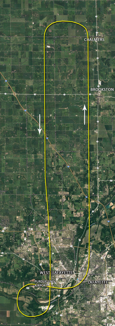
At left: my recreation or approximation of Nine-0-Nine's flight path on her tour. This is based on comparing landmarks in my photographs and those landmarks as seen in a Google Maps Satellite View. Save for the last loop, which is more simply educated guess; we were seated before the final approach, but it would be a pretzel twist like that.
Not all the photos I took came out as well as I would have liked. The flight was smooth enough, it was a good day for that, but trying to remain still as possible on the narrow deck of a bomber that is thrumming with engine vibration, plus shooting through perspex that was not cleaned to Air Corps spec - well, I was happy that, as with so many of my photos, some of them turned out pretty well (some better than others).
The order of the photographs shown here are in the order taken during the flight.
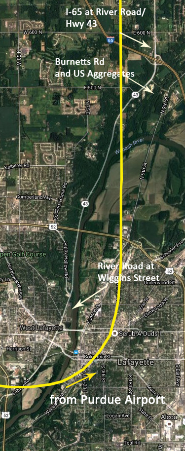
At right: map detail, with notes corresponding to the following three photographs. The arrows indicate (more or less) the angle I was shooting from.
If you're interested, there are annotated versions of the following photographs on a separate page. Of course, you're welcome to skip the captions, and just look at the pictures!
 River Rd at Wiggins St web.jpg?1498703232053)
Here, looking back across West Lafayette toward the airport. The quarter clover leaf intersection is where River Road runs under Wiggins Street. This was the view from the port side waist gun position (the barrel of the waist .50 is in the extreme lower right corner of the image).
 Burnetts Rd w US Aggregates web.jpg?1498703233343)
Stepping aft from the waist guns, I looked out the window in the rear crew door. The perspex here was a little cleaner, and as the door followed the curve of the fuselage, the window was "aimed" downward, affording a good view of the landscape passing below.
At left: the starboard horizontal with I-65 making the straight line across the photo. Burnett's Road is the short, slightly curved road in among the trees in the lower left foreground.
 I-65 at River Rd Hwy 43 web.jpg?1498703238729)
Crossing I-65. The quarter clover leaf here is the intersection with River Road or Highway 43 (depending on your referential preference).
I wouldn't go so far as to say that I had any "flash-backs" or obvious past life experiences while flying. The question of previous life experiences is something that has been discussed between me and friends or family from time to time, and the idea of having been on one of the B-17's during the war certainly came up. Why does one find an attraction to one airplane over another? Why a feeling of familiarity or comfort? Why indeed did I feel no discomfort at moving about this plane? Well, it could be that I'm just comfortable enough in my own skin, and it was an even flight so - even so, there were moments when I simply put my hands on the bare metal of the big machine and shook my head in wonder: "I'm on a B-17! Wow!" Wow was about all I could do to sum it up. Words had no real meaning for my experience of this. Wow is pretty pale as an adjective or explanation, but that's all I can speak to it. It felt - good?
 909 Starboard Wing and 50 web.jpg?1498703237851)
This photo is one that came out better than I hoped. It is also one that gives me a spooky shiver when I look at it: it could have been taken anywhere, in any year that a B-17 was flying with .50's mounted. This would have been taken around the time we were passing Brookston.
This B-17, as noted elsewhere, is not a combat veteran. It was rolled off the Douglas assembly line in 1945, but before it could be gunned up, crewed up and flown to Europe, the war there was over. It was instead pressed into service with Air/Sea Rescue, was used as a test plane in the desert to measure the effects of atomic blasts on aircraft, and then was resurrected as a fire retardant bomber before being sold to Collings. The original Nine-0-Nine flew over Berlin in 1944-45, logging a record number of non-aborted missions, and received numerous replacement parts before returning to the U.S. for scrapping.

Passing Brookston found me moving forward from the waist toward the radio room. The other passengers and I were doing a little dance around one another as we made our way from view to view.
As seen in the taxi view on the previous page, the perspex blister over the radio room had been removed, which allowed for a nice draft and a wonderful view, if you stuck your head up just a bit.
Another of our "pre-flight" warnings concerned the radio room and the lack of perspex overhead. Anything loose projected through the open dorsal could and likely would be whipped out of a hand.
The cruising speed of a 17 is 182 mph, and while we might not have been doing quite that, I think we were probably doing better than the 150 mph that we were told. Anecdotes of things lost included someone's smart phone, someone's hat (which thocked onto the vertical stabilizer necessitating an aborted flight) and the story that someone had stepped up onto the radio table and had got half-way out the window - while the plane was flying mind! - before another passenger restrained him.
Anyway, as I stepped into the radio room, I removed my hat and turned around to gasp at the view the lack of glass afforded. The plane was in its long bank to begin the return leg, and so was tipped to port, which made the view even better.
 Brookston - West of Chalmers web.jpg?1498703238117)
Above: the view from the radio room from west of Chalmers. Looking across the Meadow Lake Wind Farm toward Brookston, the town is visible just below the haze at the horizon and right of center. A slight pivot to starboard brings this view (below). The pale macadam of White County Road 500 South is plain as it emerges into sight from below the Nine-0-Nine, just left of center in the image. Beyond that can be seen the angling dark green line that marks the Dorsey Ditch. The town of Chalmers is the cluster of buildings and trees just to the left of the radio aerial post.
 White Cnty Rd 500 S - Dorsey Ditch web.jpg?1498703240210)
After spending a few minutes marveling at the view and the slipstream at the radio room, I moved through the bomb bay to the cockpit area. Most of the space is taken up by the dorsal turret framework, but I could tuck up against the port side windows behind the pilot. Whence the photo below.
West-southwest of Chalmers (the water tower is visible above the No 4 nacelle) and just before crossing the line of CR 700 S (the road to the right of the No 3 cowl).
 WSW Chalmers before CR 700 S web.jpg?1498703240226)
'cause it's what I do, I looked up the size of those wind turbines in the Meadow Lake Farm. To the top of the generator housing they stand 262 feet high, and the each of the three blades is 110 feet long. I've seen, on a couple of occasions, a blade traveling down the highway on a flatbed semi-trailer, and they are so damn huge that it's difficult to believe that the thing can be really real.
I'm only guessing, but I think our flight is probably around 800 to 900 feet altitude. I was thinking higher at first, but as can be seen here, we're not that high compared to the turbines. Plus, I believe that it's past 1,000 feet altitude that a host of flying regulations are enforced, which are probably easier dispensed with for flights like this.
From the port side, I switched to the starboard.
 I-65 at Bahler Repair web.jpg?1498703241521)
Just above and running to the left of the No 1 prop hub is the straight line of I-65 again. Just above the interstate can be seen a little cluster of buildings and trees which I believe are those belonging to a small concern named Bahler Repair. That would be Illinois out there on the horizon. In the photos looking past Brookston and Chalmers it might be possible to just make out Kokomo or Logansport in the haze 30 miles away, but I won't swear to it.
As we made our passengers' circuit of the interior, I finally came to the perspex of the bombardier's position. Wow! The flight engineer was seated in the navigator's chair, with a look like he'd seen it all before, and I guess he had. But for the rest of us, or most of the rest of us (a couple of the older folk had done this kind of plane ride on other 17's) this was still a big deal. After trying a couple shots out the side windows (yeah, they're not here for good reason), I moved up to take the short swivel chair that was planted behind the Norden bombsight.
 I-65 at White Cnty 1250 S web.jpg?1498703245064)
The view past the bombsight: looking down on I-65 just north of CR 1250 S. The Lafayettes are in the haze up there somewhere; they would be in sight in short order. The bug-spattered perspex would have some old sergeants in apoplexy I'm sure.
I probably sat there for longer than I should have, but I 'll admit I was a bit slack-jawed with the sight. Snapping a couple more shots, I made my way aft, ducking under the pilots and coming up below the dorsal turret. Others were making their way around and forward, so while I hadn't thought I would tuck up into the turret, it was really the only place I could go.
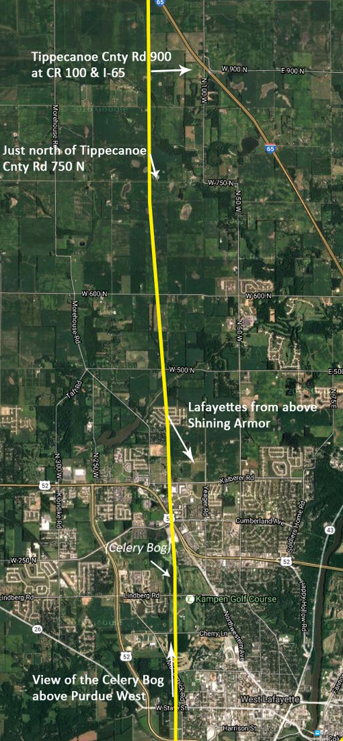
Noted at right, the two shots of the county roads were taken from the bombardier's seat, while the view of the Lafayettes was taken from the dorsal turret.
The turret was snug, to say the least, but then it was built to allow the flight engineer to fire the twin .50's, not for goggling around at the scenery. I soon stepped down and walked back to the radio room, where I snapped shots looking back north past the plane. By this point Nine-0-Nine was well over West Lafayette again, which was made readily apparent when I realized that I was looking back at the Celery Bog, a nature preserve where I had spent a few hours taking (or trying to anyhow) of birds.
At the moment I took the photo of the Bog, Nine-0-Nine was probably over the Purdue West shopping center, given the angle of the view, and that just after I took that photo the flight engineer came back and motioned for us to buckle up for the approach.
 Tippecanoe 900 N at 100 W at I-65 web.jpg?1498703244553)
Looking out the port side perspex, Tippecanoe County Roads 900 (angling down from the right) bends to meet CR 100 where CR 100 bridges across I-65. I've driven over a fair number of county roads up this-a-way, and the interstate's construction made for some tortured re-routings like this one.
Below: CR 750 N is just below, running before the farm buildings, and the Lafayettes are coming into better view ahead. The Battleground Middle School is visible at the end of the narrow, dark green swath to the left of the bombsight.
 Just North of Tippe CR 750 N - Battleground MS web.jpg?1498703244284)
 Lafayettes from above Shining Armor web.jpg?1498703244292)
Above: from the dorsal turret, looking over the cockpit. Just to the right of the No 3 prop's blur is the intersection of Kalberer Rd and Salisbury Street, while over the curve of fuselage dead ahead is the airport. I think we're over the Shining Armor residential development at this point, and the Lafayettes occupy most of the middle to distance in this photo.
Below, looking back north from the radio room. The Celery Bog is clearly visible (though not quite in focus - alas nothing is, quite, in this shot): just above the blister frame and to the left of the stabilizer, it is the flat greenish expanse ringed by trees. The white thing just above the Bog is a WalMart. Yeah, a nature preserve and a retail mega-mart, cheek-by-jowl. Ah, America!
 Celery Bog from above Purdue West web.jpg?1498703248063)
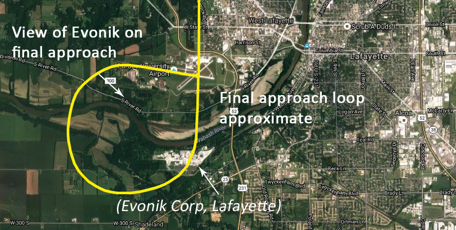
To the gestures of the engineer, I grabbed some floor in the radio room and buckled in, but kept looking around in case I might get a photograph of something. I did snap a few shots out the windows that I could get an angle on, but the angle through the perspex made focusing difficult, save for this last aerial image of the Evonik Lafayette Plant, a pharmaceutical concern on the south side of the Wabash River. This was just as the plane was coming around for its final line-up on the runway.
 Evonik Lafayette - final approach web.jpg?1498703250998)
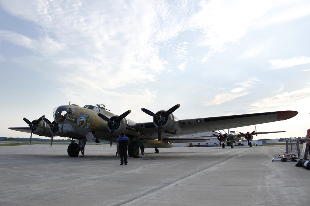
With a bump I realized that we were back on the solid ground; it was a better example of tires hitting concrete than some I've experienced on commercial flights. All too soon the flight was over, and we were piling back out on the hardstand. Nine-0-Nine had taxied back to its accustomed spot before the terminal, and the engines shut down for the night. I strolled around for another look (a longing look perhaps) and to take "just one more!" photograph. O.K., it was a several photos, but this (arty shot!) one I liked best:
TUESDAY: the flight
